

The relentless march of urbanization has propelled global city populations to unprecedented levels, creating vibrant hubs of economic activity and cultural exchange, yet simultaneously exacerbating one of the most frustrating and pervasive challenges to modern urban life: the debilitating reality of traffic congestion, which paralyzes productivity, poisons air quality, and severely erodes the overall well-being and psychological comfort of millions of daily commuters.
Traditional, static traffic management systems—relying on fixed-time signals, rigid infrastructure, and often slow, human-driven responses to incidents—have proven woefully inadequate in addressing the dynamic, unpredictable nature of modern peak-hour congestion, a phenomenon that costs the global economy billions annually in lost work hours and wasted fuel consumption.
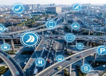
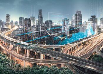
However, a profound paradigm shift is now underway, driven by the emergence of the smart city concept, which leverages ubiquitous digital connectivity and massive, real-time data streams harvested from sensors, cameras, and mobile devices to construct a detailed, living model of the city’s complex circulatory system.
This data-driven approach moves beyond mere reaction, enabling city planners and automated systems to predict bottlenecks, dynamically optimize transit routes, and implement intelligent, adaptive solutions that promise to transform the chaotic flow of urban movement into a streamlined, efficient, and responsive network.
Pillar 1: The Foundation of Data Collection
How smart cities gather the necessary real-time information to understand traffic flow.
A. Ubiquitous Sensor Networks
The physical devices forming the nervous system of the smart city.
-
Inductive Loop Detectors: These are traditional sensors embedded beneath the pavement that detect the presence and speed of vehicles passing over them, providing foundational volume data.
-
Infrared and Radar Sensors: Placed above roads, these sensors count vehicles, measure density, and track speedwith higher accuracy and across multiple lanes, even in adverse weather conditions.
-
Acoustic Sensors: These devices listen to traffic noise levels and patterns, which can be particularly useful for identifying congestion and specific types of vehicles (like heavy trucks) in noise-sensitive zones.
B. Leveraging Connected Devices
Utilizing existing personal technology for collective benefit.
-
Mobile Phone Data: Aggregated, anonymized data from cellular networks and GPS-enabled apps (like mapping services) provides the most granular, real-time picture of vehicle speeds, travel times, and current congestion levels.
-
Connected Vehicle (V2I) Data: As cars become smarter, they communicate their location, speed, and braking patterns directly to city infrastructure (Vehicle-to-Infrastructure, or V2I), offering immediate, rich operational data.
-
Bluetooth and Wi-Fi Sniffers: These non-invasive sensors detect and log the unique identifiers (MAC addresses) of passing mobile devices to track specific journey times between two points without identifying the user.
C. Video and Image Processing
Using visual data combined with Artificial Intelligence (AI).
-
High-Definition Cameras: Standard traffic cameras are enhanced with AI-powered video analytics to accurately count vehicles, classify them by type (car, bus, motorcycle), and monitor lane compliance.
-
Incident Detection: AI models are trained to automatically detect unusual events—such as a stationary vehicle, a collision, or debris on the road—triggering immediate alerts faster than human monitors can respond.
-
Pedestrian and Cyclist Monitoring: Advanced computer vision systems track the flow and volume of pedestrians and cyclists at intersections, ensuring traffic signal logic also prioritizes non-vehicular mobility for enhanced safety.
Pillar 2: Predictive Modeling and Adaptive Control
Moving beyond real-time response to proactive, preventative traffic management.
A. Real-Time Adaptive Traffic Signals
Replacing static timings with responsive, dynamic control.
-
Optimization Algorithms: Unlike old systems that change signals based on a fixed schedule, adaptive systems use AI algorithms to analyze real-time data from surrounding sensors (volume, queue length, speed).
-
Dynamic Green Waves: These systems coordinate groups of interconnected signals along a corridor to create a “green wave,” maximizing the continuous flow of traffic in the direction experiencing the heaviest demand.
-
Short-Term Prediction: The system predicts how traffic will evolve in the next 5-15 minutes based on current rates of arrival, adjusting signal timings before congestion reaches a critical, standstill level.
B. Predictive Modeling for Incident Management
Anticipating bottlenecks before they fully materialize.
-
Machine Learning Forecasting: AI models learn historical patterns—how traffic behaves on Mondays at 5:00 PM, or during light rain—to establish a baseline for normal flow.
-
Anomaly Detection: When real-time data deviates significantly from the historical norm, the system flags the anomaly and predicts potential impact, allowing managers to proactively deploy resources or change signage.
-
Event Prediction: By integrating data from city calendars (e.g., concerts, sporting events, major construction), the system models the impact on local traffic and pre-adjusts signals in advance of the event’s start and end times.
C. Dynamic Route Guidance Systems
Informing drivers to distribute traffic load across the network.
-
Variable Message Signs (VMS): Digital signs strategically placed on highways and major arteries display real-time estimated travel times and suggest alternative routes to drivers based on current congestion data.
-
Personalized Navigation Integration: City systems can share real-time data feeds directly with popular navigation apps (like Google Maps or Waze), ensuring that personalized routing advice is based on the most accurate city-wide picture.
-
Prioritizing Public Transit: These systems can ensure that public buses and emergency vehicles receive priority signaling—extending their green light when approaching an intersection—to improve reliability and response times.
Pillar 3: Integrating Multi-Modal and Public Transit

Optimizing the entire transportation ecosystem, not just private vehicles.
A. Bus Prioritization and Fleet Management
Making public transportation a reliable, preferred option.
-
Bus Signal Priority (BSP): Dedicated transponders on buses signal their imminent arrival to the traffic control system, which then grants them a short green light extension or early green, dramatically reducing dwell time at intersections.
-
Real-Time Passenger Information: Accurate GPS tracking of the bus fleet provides real-time arrival predictionsat bus stops and on mobile apps, increasing user confidence and ridership.
-
Optimizing Routes: AI algorithms analyze passenger load data and travel speeds to suggest dynamic adjustments to bus routes and schedules based on shifting demand patterns throughout the day.
B. Seamless Multi-Modal Planning
Facilitating transitions between different modes of transport.
-
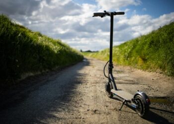
Micro-mobility Integration: City apps integrate the real-time location and availability of shared e-scooters and rental bikes alongside public transit routes, solving the “first and last mile” problem seamlessly.
-
Parking Guidance Systems: Sensors in public parking garages and on-street spots relay real-time availability to mobile apps and guidance signs, reducing the time drivers spend circling looking for parking (a major cause of congestion).
-
Transit Hub Optimization: Data monitors pedestrian flow within and around major stations to prevent dangerous bottlenecks and optimize the layout of exit gates, ticket kiosks, and connecting services.
C. Encouraging Sustainable Modes
Using data and incentives to drive behavioral change.
-
Demand-Based Pricing (Congestion Pricing): Using data to determine peak congestion times, cities can implement dynamic road tolls or access fees to discourage driving in the most congested zones during peak hours.
-
Incentive Programs: Smart apps can offer reward points or discounts on public transit or micromobility rentals to commuters who choose non-single-occupancy vehicle (SOV) modes during high-demand windows.
-
Air Quality Monitoring: Integrating real-time air quality data into traffic management decisions, potentially prioritizing traffic flow away from residential areas during periods of high localized pollution.
Pillar 4: The Operational Back-End and Security
The centralized systems and protocols that ensure data integrity and system stability.
A. The Traffic Management Center (TMC)
The central nervous system for all smart city traffic operations.
-
Unified Data Platform: The TMC houses a single, unified software platform that aggregates and visualizes all data streams (sensors, cameras, apps, weather) into a common operating picture for human analysts.
-
Decision Support Systems: AI tools provide predictive alerts and ranked response recommendations to TMC operators, who then authorize and implement changes to traffic signal timing or VMS messages.
-
Inter-Agency Coordination: The TMC serves as the central coordination point for police, fire, emergency medical services, and public works departments, ensuring rapid, synchronized response to major incidents.
B. Data Integrity and Privacy Protocols
Ensuring accuracy and protecting citizen anonymity.
-
Data Anonymization: All personal location data harvested from mobile devices must be immediately anonymized and aggregated before being used for traffic analysis to comply with privacy laws (e.g., GDPR).
-
Cybersecurity Defenses: Since traffic signals and VMS can be manipulated, the entire smart city network requires robust, multi-layered cybersecurity protocols to protect against unauthorized access or malicious attacks.
-
Sensor Calibration: Continuous remote monitoring and calibration of sensor networks are necessary to detect and correct data drift or failures, ensuring that the AI algorithms are always trained on accurate input.
C. Edge Computing and Decentralization
Moving processing power closer to the data source.
-
Faster Response Times: Edge computing involves processing sensor data directly at or near the traffic signal cabinet, enabling ultra-fast, localized decision-making without the latency of sending all data back to the central cloud.
-
Reduced Bandwidth Load: By processing raw video feeds locally and only sending summarized data (e.g., “Vehicle count is 50”), edge computing significantly reduces the required bandwidth of the network.
-
Local Adaptability: Decentralized systems allow individual intersections to retain a degree of self-sufficiency, maintaining operational adaptive control even if the connection to the central TMC is temporarily lost.
Pillar 5: Future Trajectories and Autonomous Integration
The next generation of smart city solutions and the role of autonomous vehicles.
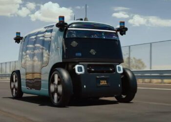
A. Preparing for Autonomous Vehicles (AVs)
Adapting infrastructure for self-driving fleets.
-
Enhanced Connectivity (V2X): Cities are deploying ubiquitous $5G$ and dedicated short-range communication (DSRC) technologies to allow AVs to communicate with infrastructure and with each other (Vehicle-to-Everything, or V2X) in real-time.
-
Digital Road Mapping: Infrastructure must support the creation of highly accurate, constantly updated digital maps that AVs rely on for navigation, lane guidance, and understanding signal status.
-
Optimized Platooning: Smart city systems will eventually coordinate the “platooning” of connected, autonomous commercial trucks on highways, dramatically increasing road capacity and fuel efficiency.
B. AI-Driven Transit Demand Management
Predicting and influencing future travel behavior.
-
Personalized Recommendations: Future apps will use AI to provide personalized transit recommendations that include incentives (e.g., “Leave 15 minutes earlier for a discount”) to subtly shift travel demand away from peak congestion points.
-
Hyperlocal Prediction: AI will be able to predict congestion on a street-by-street, minute-by-minute basis with near-perfect accuracy, allowing for preemptive signal adjustments or early public alerts.
-
Dynamic Pricing Integration: Advanced systems will integrate real-time tolling and parking fee adjustmentsbased on immediate, hyper-local congestion levels, optimizing the use of highly demanded infrastructure space.
C. Integrating Air Mobility (Drones and Air Taxis)
The eventual role of the third dimension in urban transport.
-
Low-Altitude Traffic Management (UTM): Smart cities must develop Unmanned Aircraft System Traffic Management (UTM) protocols to safely integrate commercial drone deliveries and, eventually, eVTOL (electric vertical take-off and landing) air taxis into the urban air space.
-
Vertiport Zoning: Infrastructure planning must include designating and zoning areas for “vertiports” (landing and charging hubs for air taxis), integrating them with ground transit hubs.
-
Data Synchronization: Ensuring that the UTM system communicates seamlessly with the ground TMC to manage airspace restrictions and ensure that air mobility does not impact the safety or operation of ground-based emergency services.
Conclusion: The Era of Seamless Urban Flow

The future viability of the world’s great cities hinges upon their successful, immediate transformation from gridlocked hubs into responsive, data-driven smart mobility networks.
Static traffic management systems are now obsolete, unable to cope with the complex, non-linear demands of modern urbanization, necessitating a shift to flexible, algorithmic control.
The foundation of this transformation lies in the pervasive network of sensors, cameras, and mobile devices that feed a constant, accurate torrent of real-time data into a centralized Traffic Management Center (TMC).
Moving beyond reaction, AI algorithms use this rich data to predict bottlenecks, dynamically adjust traffic signal timings along entire corridors, and proactively manage incidents before they escalate to full congestion.
Crucially, the smart city expands its focus beyond the car, using technologies like Bus Signal Priority (BSP) and integrated micromobility data to promote reliable public transit and sustainable travel options.
The next evolutionary phase involves preparing for the imminent arrival of autonomous vehicles, demanding the deployment of enhanced Vehicle-to-Everything (V2X) communication and highly detailed digital road mapping.
Ultimately, by leveraging predictive analytics and embracing multi-modal integration, smart cities are not merely fixing traffic problems, but constructing a resilient, human-centric urban environment characterized by predictable flow and significantly enhanced quality of life.

